
Naches Peak Loop
The Site
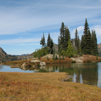
Eleven miles due east of Mount Rainer is the Naches Peak area on the crest of the Cascades Mountains. It ranges in elevation from 5,000 to 7,000 feet and lies under a heavy snow pack from late fall to late June. This is a subalpine plant community of wildflowers, Pacific silver, noble, and subalpine firs. Periodic lighting strikes have burned the area and created meadows filled with summer wildflowers. The exposed south-facing slopes have well-drained soils and a snow pack that melts out much earlier than the contrasting wet, cooler, north-facing slopes. Avalanche chutes and rocky talus slopes scar the peaks. Several small tarns or lakes are found throughout the area. The wilderness is extensive, with contiguous tracts of old-growth forest from the lower reaches around 2,000 feet to the subalpine.
The Birds
The diversity of bird species is low, but includes many higher-elevation specialties. Among the breeding birds are Blue Grouse, Northern Goshawk, Golden Eagle, Northern Pygmy-Owl, Common Nighthawk, Calliope and Rufous Hummingbirds, Hammond's Flycatcher, Clark's Nutcracker, Common Raven, Mountain Chickadee, Ruby-crowned Kinglet, Townsend's Solitaire, Hermit Thrush, American Pipit, Townsend's and possibly Hermit Warblers, Chipping Sparrow, Gray-crowned Rosy-Finch, Purple Finch, Red and White-winged Crossbills, and Evening Grosbeak. Because of the 20-foot snow pack and extreme weather conditions, few birds other than Clark's Nutcracker and Common Raven frequent the area in the winter.
From early September to early fall, raptors migrate down the crest of the Cascades. Shorebirds are found with surprising regularity around the mountain lakes, late summer through early fall. Bird species usually found east of the crest, such as Swainson's Hawk and Golden Eagle, are seen here regularly.
Directions and Suggestions
This is an exceptional site to study mountain wildflowers. Species diversity is high, trails make the area relatively accessible, and the contrast between north and south slopes is continuously interesting. The peak of the flower season is usually around the third week of July but can come later if the snow pack is heavy or the spring is cold. (For a native plant list, please see References below.)
Marmot, elk, black bear, and mountain goats occur here.
From I-5 Exit 142, take SR-18 east to Auburn. Take SR-164 southeast to Enumclaw, and exit onto SR-410. Continue east on SR-410 to Chinook Pass. This is about a two-hour drive from Seattle. Park at either Tipsoo Lake or continue about 0.5 mile east to the top of Chinook Pass. A parking pass is needed from either the Forest Service or the Park Service. No permit is needed to hike the trails.
The area is usually snow-free from the middle of July to late fall. This can vary with severity of winter conditions so check with Mount Rainier National Park headquarters on trail conditions ahead of time. There are picnic tables, water, and restrooms at Tipsoo Lake, but just restrooms at the Chinook Pass summit. The nearest food and gas service is at Greenwater on SR-410, about 30 minutes north of the park. The nearest ranger station is White River, on SR-410 about ten miles to the north. This is a very popular area on weekends, and parking fills up early in the day. Get an early start.
Be aware that mountain weather can change quickly, lighting is a concern, and snow is possible every month of the year including summer. Be prepared for winter conditions even in early summer.
Information for Mount Rainier National Park: 360-569-2211.